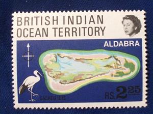
Stamp: Map (British Indian Ocean Territory 1969)
Map (British Indian Ocean Territory 1969)
10 July (British Indian Ocean Territory ) within release Aldabra Atoll goes into circulation Stamp Map face value 2.25 Seychellois rupee
| Stamp Map in catalogues | |
|---|---|
| Michel: | Mi:IO 31 |
| Stamp Number: | Sn:IO 34 |
Stamp is square format.
Stamp Map it reflects the thematic directions:
An island or isle is a piece of land, distinct from a continent, completely surrounded by water. There are continental islands, which were formed by being split from a continent by plate tectonics, and oceanic islands, which have never been part of a continent. Oceanic islands can be formed from volcanic activity, grow into atolls from coral reefs, and form from sediment along shorelines, creating barrier islands. River islands can also form from sediment and debris in rivers. Artificial islands are those made by humans, including small rocky outcroppings built out of lagoons and large-scale land reclamation projects used for development.

