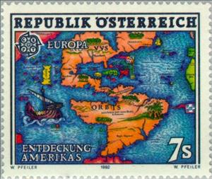
Stamp: Map of America (16th Cty.) (Austria 1992)
Map of America (16th Cty.) (Austria 1992)
08 May (Austria ) within release C.E.P.T. goes into circulation Stamp Map of America (16th Cty.) face value 7 Austrian schilling
| Stamp Map of America (16th Cty.) in catalogues | |
|---|---|
| Michel: | Mi:AT 2062 |
| Yvert et Tellier: | Yt:AT 1891 |
Stamp is horizontal format.
Stamp Map of America (16th Cty.) it reflects the thematic directions:
Cartography (/kɑːrˈtɒɡrəfi/; from Ancient Greek: χάρτης chartēs, 'papyrus, sheet of paper, map'; and γράφειν graphein, 'write') is the study and practice of making and using maps. Combining science, aesthetics and technique, cartography builds on the premise that reality (or an imagined reality) can be modeled in ways that communicate spatial information effectively.
A map is a symbolic depiction emphasizing relationships between elements of some space, such as objects, regions, or themes. Many maps are static, fixed to paper or some other durable medium, while others are dynamic or interactive. Although most commonly used to depict geography, maps may represent any space, real or imagined, without regard to context or scale, such as in brain mapping, DNA mapping, or computer network topology mapping. The space being mapped may be two dimensional, such as the surface of the earth, three dimensional, such as the interior of the earth, or even more abstract spaces of any dimension, such as arise in modeling phenomena having many independent variables. Although the earliest maps known are of the heavens, geographic maps of territory have a very long tradition and exist from ancient times. The word "map" comes from the medieval Latin Mappa mundi, wherein mappa meant napkin or cloth and mundi the world. Thus, "map" became the shortened term referring to a two-dimensional representation of the surface of the world.
The European Conference of Postal and Telecommunications Administrations (CEPT) was established on June 26, 1959, as a coordinating body for European state telecommunications and postal organizations. The acronym comes from the French version of its name Conférence européenne des administrations des postes et des télécommunications.
The Europa postage stamp (also known as Europa - CEPT until 1992) is an annual joint issue of stamps with a common design or theme by postal administrations of member countries of the European Communities (1956-1959), the European Conference of Postal and Telecommunications Administrations (CEPT) from 1960 to 1992, and the PostEurop Association since 1993. Europe is the central theme. EUROPA stamps underlines cooperation in the posts domain, taking into account promotion of philately. They also build awareness of the common roots, culture and history of Europe and its common goals. As such, EUROPA stamp issues are among the most collected and most popular stamps in the world. Since the first issue in 1956, EUROPA stamps have been a tangible symbol of Europe’s desire for closer integration and cooperation.


