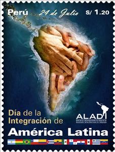
Stamp: Day of Latin American Integration (Peru 2020)
Day of Latin American Integration (Peru 2020)
17 February (Peru ) within release Day of Latin American Integration goes into circulation Stamp Day of Latin American Integration face value 1.20 Peruvian nuevo sol
| Stamp Day of Latin American Integration in catalogues | |
|---|---|
| Yvert et Tellier: | Yt: PE 2204 |
Stamp is square format.
Stamp Day of Latin American Integration it reflects the thematic directions:
Diplomacy is the main instrument of foreign policy which represents the broader goals and strategies that guide a state's interactions with the rest of the world. International treaties, agreements, alliances, and other manifestations of international relations are usually the result of diplomatic negotiation and processes. Diplomats may also help shape a state by advising government officials.
A flag is a piece of fabric (most often rectangular or quadrilateral) with a distinctive design that is used as a symbol, as a signaling device, or as decoration. The term flag is also used to refer to the graphic design employed, and flags have since evolved into a general tool for rudimentary signalling and identification, especially in environments where communication is similarly challenging (such as the maritime environment where semaphore is used). National flags are patriotic symbols with varied wide-ranging interpretations, often including strong military associations due to their original and ongoing military uses. Flags are also used in messaging, advertising, or for other decorative purposes. The study of flags is known as vexillology, from the Latin word vexillum, meaning flag or banner.
A map is a symbolic depiction emphasizing relationships between elements of some space, such as objects, regions, or themes. Many maps are static, fixed to paper or some other durable medium, while others are dynamic or interactive. Although most commonly used to depict geography, maps may represent any space, real or imagined, without regard to context or scale, such as in brain mapping, DNA mapping, or computer network topology mapping. The space being mapped may be two dimensional, such as the surface of the earth, three dimensional, such as the interior of the earth, or even more abstract spaces of any dimension, such as arise in modeling phenomena having many independent variables. Although the earliest maps known are of the heavens, geographic maps of territory have a very long tradition and exist from ancient times. The word "map" comes from the medieval Latin Mappa mundi, wherein mappa meant napkin or cloth and mundi the world. Thus, "map" became the shortened term referring to a two-dimensional representation of the surface of the world.


