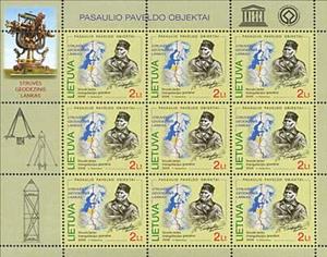
Mini Sheet: Triagulation chain of Struve arc (Lithuania 2009)
Triagulation chain of Struve arc (Lithuania 2009)
24 October (Lithuania ) within release Geographic goes into circulation Mini Sheet Triagulation chain of Struve arc face value 10*2 Lithuanian litas
| Mini Sheet Triagulation chain of Struve arc in catalogues | |
|---|---|
| Michel: | Mi: LT 1023KB |
Mini Sheet is square format.
Friedrich Georg Wilhelm von Struve, AstronomerAlso in the issue Geographic:
- Stamp - The World Heritage Objects face value 2;
- Stamp - The World Heritage Objects face value 2;
- Mini Sheet - Point in Meshkonys of Struve’s arc face value 10*2;
- Mini Sheet - Triagulation chain of Struve arc face value 10*2;
Mini Sheet Triagulation chain of Struve arc it reflects the thematic directions:
An astronomer is a scientist in the field of astronomy who focuses their studies on a specific question or field outside the scope of Earth. They observe astronomical objects such as stars, planets, moons, comets and galaxies – in either observational (by analyzing the data) or theoretical astronomy. Examples of topics or fields astronomers study include planetary science, solar astronomy, the origin or evolution of stars, or the formation of galaxies. A related but distinct subject is physical cosmology, which studies the Universe as a whole
Geodesy is the science of measuring and representing the geometry, gravity, and spatial orientation of the Earth in temporally varying 3D. It is called planetary geodesy when studying other astronomical bodies, such as planets or circumplanetary systems
A map is a symbolic depiction emphasizing relationships between elements of some space, such as objects, regions, or themes. Many maps are static, fixed to paper or some other durable medium, while others are dynamic or interactive. Although most commonly used to depict geography, maps may represent any space, real or imagined, without regard to context or scale, such as in brain mapping, DNA mapping, or computer network topology mapping. The space being mapped may be two dimensional, such as the surface of the earth, three dimensional, such as the interior of the earth, or even more abstract spaces of any dimension, such as arise in modeling phenomena having many independent variables. Although the earliest maps known are of the heavens, geographic maps of territory have a very long tradition and exist from ancient times. The word "map" comes from the medieval Latin Mappa mundi, wherein mappa meant napkin or cloth and mundi the world. Thus, "map" became the shortened term referring to a two-dimensional representation of the surface of the world.
Elements of industrial instrumentation have long histories. Scales for comparing weights and simple pointers to indicate position are ancient technologies. Some of the earliest measurements were of time. One of the oldest water clocks was found in the tomb of the ancient Egyptian pharaoh Amenhotep I, buried around 1500 BCE. Improvements were incorporated in the clocks. By 270 BCE they had the rudiments of an automatic control system device.
The United Nations Educational, Scientific and Cultural Organization (UNESCO; pronounced /juːˈnɛskoʊ/) is a specialized agency of the United Nations (UN) with the aim of promoting world peace and security through international cooperation in education, arts, sciences and culture. It has 194 member states and 12 associate members,as well as partners in the non-governmental, intergovernmental and private sector. Headquartered in Paris, France, UNESCO has 53 regional field offices and 199 national commissions


