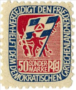
Stamp: Propaganda stamp for Greek Communist Army (Germany, Democratic Republic 1949)
Propaganda stamp for Greek Communist Army (Germany, Democratic Republic 1949)
01 January (Germany, Democratic Republic ) within release Propaganda stamp for Greek Communist Army goes into circulation Stamp Propaganda stamp for Greek Communist Army face value 50 East German pfennig
| Stamp Propaganda stamp for Greek Communist Army in catalogues | |
|---|---|
| Colnect codes: | Col: DD 1949-04 |
Stamp is vertical format.
From Soviet Occupation Zone,1949Also in the issue Propaganda stamp for Greek Communist Army:
- Stamp - Propaganda stamp for Greek Communist Army face value 10;
- Stamp - Propaganda stamp for Greek Communist Army face value 50;
Stamp Propaganda stamp for Greek Communist Army it reflects the thematic directions:
Communism (from Latin communis, 'common, universal') is a left-wing to far-left sociopolitical, philosophical, and economic ideology within the socialist movement, whose goal is the creation of a communist society, a socioeconomic order centered around common ownership of the means of production, distribution, and exchange that allocates products to everyone in the society based on need. A communist society would entail the absence of private property and social classes, and ultimately moneyand the state (or nation state).
A flag is a piece of fabric (most often rectangular or quadrilateral) with a distinctive design that is used as a symbol, as a signaling device, or as decoration. The term flag is also used to refer to the graphic design employed, and flags have since evolved into a general tool for rudimentary signalling and identification, especially in environments where communication is similarly challenging (such as the maritime environment where semaphore is used). National flags are patriotic symbols with varied wide-ranging interpretations, often including strong military associations due to their original and ongoing military uses. Flags are also used in messaging, advertising, or for other decorative purposes. The study of flags is known as vexillology, from the Latin word vexillum, meaning flag or banner.
A map is a symbolic depiction emphasizing relationships between elements of some space, such as objects, regions, or themes. Many maps are static, fixed to paper or some other durable medium, while others are dynamic or interactive. Although most commonly used to depict geography, maps may represent any space, real or imagined, without regard to context or scale, such as in brain mapping, DNA mapping, or computer network topology mapping. The space being mapped may be two dimensional, such as the surface of the earth, three dimensional, such as the interior of the earth, or even more abstract spaces of any dimension, such as arise in modeling phenomena having many independent variables. Although the earliest maps known are of the heavens, geographic maps of territory have a very long tradition and exist from ancient times. The word "map" comes from the medieval Latin Mappa mundi, wherein mappa meant napkin or cloth and mundi the world. Thus, "map" became the shortened term referring to a two-dimensional representation of the surface of the world.


