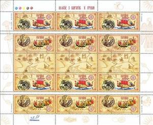
Mini Sheet: Ancient Trade Route along the Gulf of Finland and the Dniepe (Ukraine 2003)
Ancient Trade Route along the Gulf of Finland and the Dniepe (Ukraine 2003)
17 September (Ukraine ) within release Trade Route along the Gulf of Finland and the Dnieper goes into circulation Mini Sheet Ancient Trade Route along the Gulf of Finland and the Dniepe face value 9.60 Ukrainian hryvnia
| Mini Sheet Ancient Trade Route along the Gulf of Finland and the Dniepe in catalogues | |
|---|---|
| Michel: | Mi:UA 598-599 Klb |
Mini Sheet is square format.
Also in the issue Trade Route along the Gulf of Finland and the Dnieper:
- Booklet - Ancient Trade Route along the Gulf of Finland and the Dniepe face value 2.40;
- Mini Sheet - Ancient Trade Route along the Gulf of Finland and the Dniepe face value 9.60;
- Se-tenant - Ancient Trade Route along the Gulf of Finland and the Dniepe face value 1.60;
Mini Sheet Ancient Trade Route along the Gulf of Finland and the Dniepe it reflects the thematic directions:
A ship is a large watercraft that travels the world's oceans and other sufficiently deep waterways, carrying passengers or goods, or in support of specialized missions, such as defense, research and fishing. Historically, a "ship" was a sailing vessel with at least three square-rigged masts and a full bowsprit. Ships are generally distinguished from boats, based on size, shape and load capacity.
A map is a symbolic depiction emphasizing relationships between elements of some space, such as objects, regions, or themes. Many maps are static, fixed to paper or some other durable medium, while others are dynamic or interactive. Although most commonly used to depict geography, maps may represent any space, real or imagined, without regard to context or scale, such as in brain mapping, DNA mapping, or computer network topology mapping. The space being mapped may be two dimensional, such as the surface of the earth, three dimensional, such as the interior of the earth, or even more abstract spaces of any dimension, such as arise in modeling phenomena having many independent variables. Although the earliest maps known are of the heavens, geographic maps of territory have a very long tradition and exist from ancient times. The word "map" comes from the medieval Latin Mappa mundi, wherein mappa meant napkin or cloth and mundi the world. Thus, "map" became the shortened term referring to a two-dimensional representation of the surface of the world.
A joint issue is the release of stamps or postal stationery by two or more countries to commemorate the same topic, event or person. Joint issues typically have the same first day of issue and their design is often similar or identical, except for the identification of country and value.


