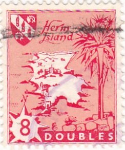
Stamp: Herm Island Map (Cinderellas 1959)
Herm Island Map (Cinderellas 1959)
01 January (Cinderellas ) within release Guernsey-Herm goes into circulation Stamp Herm Island Map face value 8 Guernsey double
| Stamp Herm Island Map in catalogues | |
|---|---|
| Colnect codes: | Col: GH-1959-02 |
Stamp is square format.
Also in the issue Guernsey-Herm:
- Stamp - M.L. arrowhead leaves Herm for Guernesey with mail face value 3;
- Stamp - M.L. arrowhead enters St. Peter Port Harbour, Guernsey face value 1'6;
- Stamp - M.L.arrowhead at sea south of Brehon tower face value 6;
- Stamp - Herm Island Map face value 4;
- Stamp - Herm Island Map face value 8;
- Stamp - Herm Island Map face value 1½;
|
Data entry completed
46%
|
|
|---|---|
| Stamp Herm Island Map in digits | |
| Country: | Cinderellas |
| Date: | 1959-01-01 |
| Emission: | Definitive |
| Format: | Stamp |
| Face Value: | 8 Guernsey double |
Stamp Herm Island Map it reflects the thematic directions:
Coastal areas are local administrative units (LAUs) that are bordering or close to a coastline. A coastline is defined as the line where land and water surfaces meet (border each other).
The Arecaceae is a family of perennial, flowering plants in the monocot order Arecales. Their growth form can be climbers, shrubs, tree-like and stemless plants, all commonly known as palms. Those having a tree-like form are called palm trees. Currently, 181 genera with around 2,600 species are known,
most of which are restricted to tropical and subtropical climates. Most palms are distinguished by their large, compound, evergreen leaves, known as fronds, arranged at the top of an unbranched stem, except for the Hyphaene genus, who has branched palms. However, palms exhibit an enormous diversity in physical characteristics and inhabit nearly every type of habitat within their range, from rainforests to deserts.
A sea is a large body of salty water. There are particular seas and the sea. The sea commonly refers to the World Ocean, the wider body of seawater. Particular seas are either marginal seas, second-order sections of the oceanic sea (e.g. the Mediterranean Sea), or certain large, nearly landlocked bodies of water.


