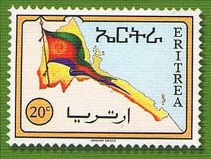
Stamp: Eritrean flag and map (Eritrea 1996)
Eritrean flag and map (Eritrea 1996)
25 December (Eritrea ) within release 1st Year of Independence goes into circulation Stamp Eritrean flag and map face value 20 Ethiopian cent
| Stamp Eritrean flag and map in catalogues | |
|---|---|
| Stanley Gibbons: | Sg: ER 277A |
Stamp is horizontal format.
Map pf Eritrea with Hanish archipelagoAlso in the issue 1st Year of Independence:
- Stamp - Eritrean map and flag face value 3;
- Stamp - Eritrean map and flag face value 60;
- Stamp - Eritrean flag and map face value 20;
- Stamp - Eritrean map and flag face value 40;
Stamp Eritrean flag and map it reflects the thematic directions:
A flag is a piece of fabric (most often rectangular or quadrilateral) with a distinctive design that is used as a symbol, as a signaling device, or as decoration. The term flag is also used to refer to the graphic design employed, and flags have since evolved into a general tool for rudimentary signalling and identification, especially in environments where communication is similarly challenging (such as the maritime environment where semaphore is used). National flags are patriotic symbols with varied wide-ranging interpretations, often including strong military associations due to their original and ongoing military uses. Flags are also used in messaging, advertising, or for other decorative purposes. The study of flags is known as vexillology, from the Latin word vexillum, meaning flag or banner.

