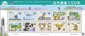
Mini Sheet: 150th Anniversary of the Geospatial Information Authority (Japan 2019)
150th Anniversary of the Geospatial Information Authority (Japan 2019)
03 June (Japan ) within release 150th Anniversary of the Geospatial Information Authority goes into circulation Mini Sheet 150th Anniversary of the Geospatial Information Authority face value 10*82 Japanese yen
| Mini Sheet 150th Anniversary of the Geospatial Information Authority in catalogues | |
|---|---|
| Colnect codes: | Col: JP 2019-16 |
Mini Sheet is square format.
Also in the issue 150th Anniversary of the Geospatial Information Authority:
- Stamp - 150th Anniversary of the Geospatial Information Authority face value 82;
- Stamp - 150th Anniversary of the Geospatial Information Authority face value 82;
- Mini Sheet - 150th Anniversary of the Geospatial Information Authority face value 10*82;
- Stamp - 150th Anniversary of the Geospatial Information Authority face value 82;
- Stamp - 150th Anniversary of the Geospatial Information Authority face value 82;
- Stamp - 150th Anniversary of the Geospatial Information Authority face value 82;
- Stamp - 150th Anniversary of the Geospatial Information Authority face value 82;
- Stamp - 150th Anniversary of the Geospatial Information Authority face value 82;
- Stamp - 150th Anniversary of the Geospatial Information Authority face value 82;
- Stamp - 150th Anniversary of the Geospatial Information Authority face value 82;
- Stamp - 150th Anniversary of the Geospatial Information Authority face value 82;
Mini Sheet 150th Anniversary of the Geospatial Information Authority it reflects the thematic directions:
An aircraft (pl. aircraft) is a vehicle that is able to fly by gaining support from the air. It counters the force of gravity by using either static lift or the dynamic lift of an airfoil, or, in a few cases, direct downward thrust from its engines. Common examples of aircraft include airplanes, rotorcraft (including helicopters), airships (including blimps), gliders, paramotors, and hot air balloons.Part 1 (Definitions and Abbreviations) of Subchapter A of Chapter I of Title 14 of the U. S. Code of Federal Regulations states that aircraft "means a device that is used or intended to be used for flight in the air."
A computer is a machine that can be programmed to automatically carry out sequences of arithmetic or logical operations (computation). Modern digital electronic computers can perform generic sets of operations known as programs. These programs enable computers to perform a wide range of tasks. The term computer system may refer to a nominally complete computer that includes the hardware, operating system, software, and peripheral equipment needed and used for full operation; or to a group of computers that are linked and function together, such as a computer network or computer cluster.
Geodesy is the science of measuring and representing the geometry, gravity, and spatial orientation of the Earth in temporally varying 3D. It is called planetary geodesy when studying other astronomical bodies, such as planets or circumplanetary systems


